
Alliance
Jokeri Light Rail (Finnish: Raidejokeri) is implemented with the alliance model. This means that the client organization formed by the cities of Helsinki and Espoo will be combined into one organization, together with the designers and the contractors. The designers are Ramboll Finland, Sitowise and NRC Finland. YIT and NRC Finland are the contractors of the line. The parties to the alliance will design and construct the track together, sharing the risks and benefits related to the project’s implementation.
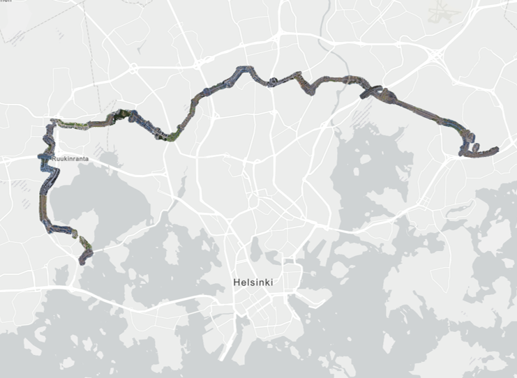
The Jokeri Light Rail line will be built between Itäkeskus in Helsinki and Keilaniemi in Espoo. The planned length of the line is approximately 25 km (15.5 miles), of which 16 km will be in Helsinki and the remaining 9 km in Espoo. Jokeri Light Rail will replace trunk bus line 550, which is the busiest bus line in the Helsinki region.
Näytä tämä julkaisu Instagramissa.
Source and more info: https://raidejokeri.info/en/jokeri-light-rail-from-itakeskus-to-keilaniemi/
Goals
The Jokeri Light Rail is constructed from June 2019 to June 2024. The project uses drones to monitor and document the progress of the long construction site. No one can get a clear overview of what and where is something happening with only worksite visits and meetings. Orthoimages generated from drone captures support the overall understanding of the situation for designers, traffic planners, construction workers and project management. The goal is to distribute the generated aerial maps as quickly as possible to as many software as possible so that all stakeholders working on the Jokeri Light Rail will benefit from the situation awareness.
Solution
Pointscene offered an automated web service to obtain the most recent aerial images of the whole area. The project is now running over 700 orthophotos and still counting. Every time a new drone dataset is added to Pointscene, it is automatically updated to the web service link (e.g. WMTS) that is integrated with other software like Infrakit and Louhi. Data is uploaded only once and centrally stored and it is automatically distributed via web services to all users. The Jokeri Light Rail does about 15 drone flights a week when the weather is suitable.
WTMS Compilation web service integrated into ArcGIS Online.
Results
Now the Jokeri Light Rail has 100 times faster process for updating orthoimages in their software of choice.